Introduction: The Sky-High Advantage in Real Estate
In today's crowded digital marketplace, standard photos simply don't cut it. Buyers scroll past listings that fail to capture the full story of a property, leaving sellers with longer market times and lower offers. But what if you could instantly showcase not just the house, but the entire lifestyle it offers? Aerial photography for real estate is that transformative solution, providing a comprehensive, bird's-eye view that captures the property, lot, and neighborhood context in a single, compelling image.
This isn't a luxury; it's a data-backed marketing necessity. Consider this: listings with aerial photography sell 68% faster and receive 87% more views online. This definitive guide for agents and serious sellers will show you how to leverage this powerful tool to highlight unique features, create immersive experiences, and ultimately, close deals faster and for more money. We'll cut through the complexity, focusing on the practical strategies and professional standards you need to know to gain a decisive edge.
Why Aerial Photography is a Game-Changer for Selling Homes
Aerial photography for real estate is no longer a luxury; it's a data-backed marketing essential that provides a competitive edge and accelerates sales. By capturing the full scope of a property—the home itself, the lot size, and the neighborhood context—you give potential buyers a comprehensive understanding they simply can't get from ground-level photos alone. In fact, properties with drone photos receive 87% more views online, proving its power to capture attention in a crowded digital marketplace.
This perspective is invaluable for highlighting a property's most desirable features. A large backyard, a swimming pool, a new roof, or proximity to parks and water are all showcased effectively from above. Drone photography, the most common and cost-effective method, makes this possible, allowing you to tell a complete visual story that makes your listing stand out and justifies its value.
To ensure quality and compliance, always hire a professional with an FAA Part 107 certification for commercial drone use. The investment is minimal compared to the returns, as compelling aerial imagery directly influences buyer perception and engagement. Ultimately, integrating aerial shots and video into your marketing creates an immersive experience that builds buyer confidence and can lead to faster, higher offers.
Providing Crucial Context and Scale
Ground-level photos can't capture the full story of a property. Aerial photography provides the crucial context and scale that buyers need, showcasing the entire lot, the home's footprint, and its relationship to the neighborhood. This comprehensive perspective instantly clarifies the property's true size, layout, and proximity to desirable features like parks or water.
By revealing the complete picture—from the condition of the roof to the size of the backyard—aerial shots answer key buyer questions before they even schedule a showing. This level of transparency builds confidence and helps your listing stand out as an informed and professional offering.
Highlighting Unique Selling Points from Above
Aerial photography is the ultimate tool for showcasing a property’s most desirable features. A standard ground-level shot can’t capture the full scale of a resort-style pool, a sprawling private yard, or the elegant symmetry of professional landscaping. From above, you clearly demonstrate the property’s valuable context—its proximity to water, parks, or other neighborhood amenities that buyers actively seek.
This elevated perspective transforms abstract descriptions into compelling visual proof, making your listing more memorable and significantly more attractive to potential buyers browsing online.
The Data: How Aerial Imagery Boosts Engagement and Value
The numbers speak for themselves. Properties featuring professional aerial photography don't just look better—they perform better. Listings with drone photos sell 68% faster and attract 87% more online views. This increased exposure directly translates to financial value, with the potential to increase final offer prices by up to 10%.
This powerful ROI stems from the comprehensive perspective aerial shots provide. They instantly communicate the property's full scope, including the lot size, roof condition, and proximity to desirable amenities, building immediate buyer confidence and perceived value.
Drone Photography vs. Traditional Aerial Methods
For residential real estate, drone photography has decisively replaced traditional methods like helicopters or planes as the superior, cost-effective choice. While helicopters can capture similar angles, they come with significant drawbacks that make them impractical for most home listings.
Drones offer unparalleled flexibility, allowing photographers to capture unique perspectives—from a sweeping bird’s-eye view down to a detailed shot of a backyard patio—all for a fraction of the cost and logistical hassle of a helicopter. This makes professional aerial photography for real estate accessible for virtually any property, not just high-end luxury homes. The data supports this shift: properties with drone photos receive up to 87% more views online, proving their immense marketing value.
Beyond cost and agility, drones provide a quieter, less intrusive experience for the neighborhood and enable the creation of seamless, immersive content like virtual tours. When you choose a drone service, you are not just getting a photo; you are investing in a comprehensive marketing tool that showcases the entire property and its context, helping it stand out and sell faster.
Navigating FAA Regulations for Real Estate Drone Use
Operating a drone for commercial real estate marketing is not a casual endeavor; it is a regulated activity that requires an FAA Part 107 certification. Hiring a certified professional is non-negotiable for mitigating legal risk and ensuring your marketing campaign is fully compliant. Flying without this license can result in significant fines and jeopardize the sale.
An FAA-certified pilot possesses the knowledge to navigate critical airspace restrictions, secure necessary authorizations, and operate the drone safely around people and property. This expertise is essential for capturing stunning aerial photography for real estate without legal complications. The regulations are in place for safety and privacy, and a professional operator manages these complexities on your behalf.
The value of using a certified expert is clear: properties with professional drone photos receive up to 87% more views online. By entrusting this task to a licensed pilot, you not only protect yourself from liability but also leverage a powerful marketing tool that delivers proven results. This ensures your listing stands out while adhering to all federal aviation standards.
Understanding the FAA Part 107 Certification
For any commercial real estate shoot, the drone pilot must hold an FAA Part 107 Remote Pilot Certificate. This isn't a suggestion—it's federal law. This certification ensures the operator is thoroughly trained in critical areas like:
- National airspace regulations
- Safety protocols
- Weather effects on flight
Hiring a Part 107 certified professional protects you from significant fines and liability, guaranteeing your marketing is both stunning and fully compliant. It’s the non-negotiable foundation of legal and professional aerial photography.
Key Operational Rules and Safety Protocols
Operating a drone for real estate is governed by strict FAA regulations to ensure safety and privacy. A certified Part 107 pilot must always maintain a visual line of sight with the aircraft and adhere to a 400-foot altitude limit. Key operational rules include:
- Strictly avoiding no-fly zones, such as those near airports.
- Never flying directly over unprotected people or private property without permission.
- Conducting pre-flight checks for weather and equipment.
Adhering to these protocols is non-negotiable for a professional and legal marketing shoot.
The Real Estate Aerial Shot List: Capturing What Sells
A strategic aerial shot list is essential for showcasing your property's most compelling features and driving serious buyer interest. To tell a complete story, focus on capturing these key perspectives:
- The Hero Shot: A direct overhead, bird's-eye view that establishes the property's full layout, lot size, and relationship to its boundaries.
- The Approach: An angled shot from the front, simulating the buyer's arrival to highlight curb appeal and the home's position in the neighborhood.
- The Lifestyle Shot: Low-altitude, angled photos that emphasize specific amenities like a swimming pool, spacious deck, or extensive landscaping.
Integrating aerial photography for real estate into your marketing plan is a proven strategy to capture attention. Properties with professional drone photos receive up to 87% more views online, making your listing stand out in a crowded digital marketplace. These images provide context that ground-level photos simply cannot, illustrating the home's proximity to desirable features like water, parks, or a quiet cul-de-sac.
Ultimately, a well-executed aerial shot list does more than just take pictures from the sky; it builds a narrative. It allows potential buyers to visualize their life on the property, understanding the flow of the land and the unique value proposition. This comprehensive visual package builds confidence, answers critical questions upfront, and motivates buyers to take the next step.
The Essential Overhead (Bird's-Eye) Shot
The straight-down, bird's-eye view is a non-negotiable asset for any serious property listing. This unique perspective provides an immediate and comprehensive understanding of the property's entire layout, showcasing the flow between the house, yard, and other structures in a way ground-level photos cannot. It clearly defines lot boundaries and offers a transparent look at the roof's condition, preemptively answering critical buyer questions.
By capturing the full scope of the land and its relationship to the neighborhood, this single shot establishes scale and context, making the property feel larger and more substantial. It’s the ultimate tool for highlighting prized amenities like pools, patios, and sprawling gardens, instantly elevating a listing from standard to exceptional.
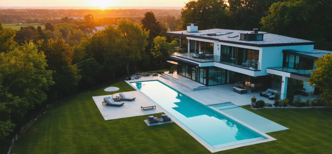
The 45-Degree Angle Hero Shot
The 45-degree aerial shot is the definitive hero image for a property listing. This specific perspective masterfully captures the home's full facade, the entire yard, and the property's relationship to its surroundings in a single, aspirational frame. It allows potential buyers to instantly visualize the complete package—the home, the land, and the lifestyle it offers.
By showcasing the roof condition, landscaping, and outdoor amenities like a pool or patio, this comprehensive view builds an immediate emotional connection. It answers critical questions about scale and setting before a buyer even clicks, making your listing far more compelling and informative than those relying on ground-level photos alone.
Orbital and Panoramic Shots for Immersion
Move beyond static top-down photos with orbital and panoramic shots that actively sell the lifestyle. An orbital shot gracefully circles the property, creating a dynamic, movie-like preview that showcases the home from every angle and establishes its presence on the lot. Meanwhile, wide panoramic captures reveal the full context of the neighborhood, nearby parks, or water access, telling a compelling story about the location. These advanced techniques transport potential buyers, offering a truly immersive experience that builds an emotional connection before they ever step foot on the property.
Best Practices for Stunning Aerial Real Estate Photos
To capture stunning aerial real estate photos that truly sell, meticulous planning around timing, weather, and preparation is non-negotiable. Properties with drone photos receive 87% more views online, making this a critical step for maximizing your listing's impact.
The single most important factor is lighting. Schedule your shoot for the ‘golden hours'—shortly after sunrise or before sunset—when the sun is low in the sky, casting soft, warm light that minimizes harsh shadows and glare. This flatters the property's architecture and landscaping. Always check the weather forecast, opting for a clear day with minimal wind to ensure a stable drone and crisp, clear images. A successful session of aerial photography for real estate hinges on this foundational preparation.
Before the drone even takes off, a thorough site walkthrough is essential. Identify and communicate the key selling points you want to highlight, such as the pool, spacious yard, or the property's proximity to desirable amenities like parks or water. Ensure the property is ‘camera-ready' from above; this means tidy landscaping, a clean pool, and cleared patios. By coordinating these elements with your certified FAA Part 107 pilot, you guarantee a smooth, efficient shoot that produces compelling, market-ready visuals.
Timing is Everything: The Golden Hour and Weather
For stunning aerial photos that sell, timing is your most powerful tool. The ‘golden hours'—just after sunrise and before sunset—provide soft, warm, directional light that eliminates harsh shadows and makes any property look its absolute best. This flattering light accentuates architectural details and lush landscaping, creating an immediate emotional connection with potential buyers.
Equally critical is the weather. A clear, calm day is non-negotiable. Not only does it ensure crisp, bright images, but it also provides a safe flying environment for your drone operator. Overcast or windy conditions can result in dull, blurry photos that fail to showcase your listing's true potential.
Preparing the Property for its Aerial Debut
An aerial shoot captures everything, so meticulous preparation is non-negotiable. Start with the yard: mow the lawn, trim hedges, and clear any clutter like children's toys, garden hoses, and trash bins. A pristine landscape from above signals a well-maintained property.
Pay special attention to key features. If you have a pool, ensure the water is crystal clear and the cover is completely removed. Neatly arrange patio furniture and ensure driveways and walkways are swept. These details, often missed from the ground, become prominent selling points from a bird's-eye view.
Beyond Photos: Integrating Aerial Footage into Virtual Tours and Video
To truly dominate the market, you must move beyond static images and integrate aerial photography for real estate into dynamic virtual tours and video walkthroughs, creating an unparalleled, immersive buyer experience.
By stitching breathtaking aerial shots of the property’s exterior, lot, and neighborhood context into a virtual tour, you provide a seamless narrative. A buyer can transition from walking through the living room to soaring above the backyard pool, understanding the property's scale and proximity to parks or water in a way ground-level photos simply cannot convey. This comprehensive perspective is critical; in fact, properties with drone photos receive 87% more views online.
For video marketing, aerial footage serves as the perfect opening and closing sequence, establishing the home’s grandeur and setting. This powerful combination of media formats not only captivates potential buyers but also significantly boosts perceived value. To execute this effectively:
- Start videos with a sweeping aerial approach to grab attention immediately.
- Weave aerial clips throughout the video to highlight key exterior features.
- Use a bird’s-eye view to conclude the tour, reinforcing the property’s full scope and leaving a lasting impression.
Crafting a Seamless Aerial-to-Ground Video Walkthrough
Begin your property video with a sweeping aerial shot to immediately capture attention and establish the home's context within its neighborhood. This grand opening sets a cinematic tone, showcasing the entire lot, key exterior features, and proximity to desirable amenities from a unique perspective.
Then, smoothly transition to the ground-level interior walkthrough. This powerful narrative flow—from the macro view to the intimate details—guides potential buyers on a logical and emotionally engaging journey. It connects the property's external appeal with its internal living spaces, creating a compelling, professional presentation that stands out.
Boosting Virtual Tours with Interactive Aerial Views
Integrating aerial photography into interactive 3D tours, such as Matterport, transforms a standard walkthrough into an immersive experience. While the virtual tour showcases the home's interior, an interactive aerial view provides crucial context, allowing potential buyers to instantly understand the property's full scope, the lot size, and its relationship to the neighborhood.
This seamless blend of ground-level and bird's-eye perspectives gives buyers the confidence that comes from a complete understanding of the property, significantly boosting engagement and making your listing far more memorable than standard photos alone. For a deeper dive into creating these experiences, explore our guide to free 3D virtual tour apps.
Choosing the Right Professional Drone Photographer
Selecting a qualified drone photographer is a critical step to ensure you receive professional, legal, and high-quality results that enhance your listing. While many offer drone services, not all operators are created equal, and the right choice protects you from liability while maximizing visual impact.
Your first and most important criterion should be verifying the photographer holds a valid FAA Part 107 certification, which is legally required for all commercial real estate drone photography in the U.S. A certified operator understands airspace regulations, safety protocols, and carries the necessary insurance. Beyond legality, review their portfolio for sharp, well-composed images that effectively showcase properties similar to yours. Look for experience with the specific shots that sell homes, such as compelling overhead views that highlight the entire lot and its context within the neighborhood.
To streamline your selection process, use this checklist:
- FAA Part 107 Certified: Request proof of their license.
- Insurance: Confirm they carry liability coverage.
- Portfolio & References: Assess quality and experience with real estate.