Introduction: Elevating Real Estate Listings with Drone Photography
In the competitive Davenport, Florida real estate market, standard property photos are no longer enough to capture a buyer's imagination. The challenge for agents and homeowners is presenting a property's full potential—its scale, its relationship to the surrounding community, and its unique features—in a way that static ground-level shots simply cannot. Drone photography provides the definitive solution, transforming listings with breathtaking aerial perspectives that showcase everything from the property's footprint and lot size to its proximity to local amenities and the stunning Florida landscape. These powerful visuals are not just decorative; they are a critical marketing tool that can significantly reduce time on market. This guide delivers essential drone photography tips to help you master the art of the aerial shot, ensuring your property stands out. We will cover everything from optimal flight timing and composition techniques to navigating local regulations, empowering you to create stunning, professional-grade imagery that captivates potential buyers from the first click.
Essential Drone Equipment and Flight Basics
Mastering your drone equipment and flight fundamentals is the first step to capturing professional real estate photos that stand out in the Davenport market. For real estate work, your core kit should include a drone with a high-quality camera (like a DJI model), multiple charged batteries to extend your shooting session, ND filters to manage Florida's bright sunlight, and a reliable tablet for monitoring your shots. Before every flight, a thorough pre-flight check is non-negotiable for safety and compliance. This includes inspecting the drone for damage, calibrating the compass, verifying GPS signal, and confirming you are operating within FAA regulations, which is especially important in Central Florida's varied airspace.
Once airborne, focus on stable flight operation. Key practices for getting clean shots include:
• Maintaining a steady hover for sharp images
• Using slow, smooth movements for cinematic video
• Keeping a safe altitude above people and property
• Monitoring battery levels to ensure a safe return
• Being aware of wind conditions which can affect stability
Confident control allows you to focus on composition, ensuring you capture the property's best angles and surrounding landscape from a compelling aerial perspective.
Composition Techniques for Compelling Aerial Shots
Mastering aerial composition is the key to transforming a simple overhead shot into a compelling narrative that showcases a property's best features. The fundamental rule of thirds remains as powerful from the air as it is on the ground; position key elements like the property's roofline, pool, or landscaping along the grid lines to create a balanced and professional image. For real estate in the Davenport area, this means framing the home to highlight its relationship with the lot, nearby water features, or community amenities, guiding the viewer's eye naturally through the scene. Leading lines are another powerful tool—use driveways, fences, or property boundaries to create depth and draw attention directly to the residence.
Altitude and perspective are your most creative controls in aerial photography. While a high, straight-down shot provides essential context for the property's size and location, don't underestimate the impact of lower-angle oblique shots. These perspectives can make a home feel more grand and inviting. For maximum creative control in post-production, always shoot in RAW format. This is especially critical for capturing the vibrant Florida skies and lush landscapes, allowing you to recover details in both shadows and highlights.
Effective composition for real estate involves a strategic mix of shots:
• Eye-level approach shots that mimic a buyer's first view
• 45-degree angles highlighting the property's facade and depth
• Top-down views illustrating the full property layout
• Wide establishing shots showing the home in its neighborhood context
By varying your altitude and angle, you create a comprehensive visual story that static ground photos cannot match.
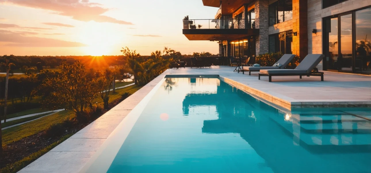
Mastering Lighting and Optimal Shooting Times
Mastering lighting is the single most critical factor for creating stunning aerial real estate photos that capture a property's true appeal. The time of day and weather conditions dramatically impact the mood, color, and overall quality of your shots, transforming a standard listing into an exceptional one. For properties in the Davenport area, the warm, diffused light of the golden hour—the first hour after sunrise and the last hour before sunset—provides optimal conditions by minimizing harsh shadows and creating a flattering, inviting glow on buildings and landscapes. This soft light enhances architectural details and makes lush Florida greenery appear more vibrant. Shooting during this window ensures you capture the property in its most attractive state. Key lighting considerations for real estate include: shooting during golden hour for warm, soft light, avoiding midday sun to prevent harsh shadows and blown-out highlights, utilizing overcast days for even, shadow-free illumination, planning shoots for clear weather with good visibility, and positioning the sun behind the drone to evenly light the property's facade. Beyond the golden hour, understanding how to work with different weather conditions is essential. A lightly overcast day can act as a giant softbox, providing beautifully even lighting that is ideal for capturing accurate colors and details without extreme contrasts. Always check the forecast and be prepared to reschedule if high winds or precipitation are expected, as these conditions not only produce poor images but can also pose safety risks for your equipment.
Pro Camera Settings and Flight Planning
Mastering your drone's camera settings and planning your flight path are the most critical steps for capturing professional real estate photos. For the best results, always shoot in RAW format to preserve maximum image data for post-processing, and schedule your shoots during the golden hour—the first hour after sunrise or before sunset—to take advantage of Davenport's beautiful, soft Florida light that enhances property appeal. Proper planning ensures you capture all necessary angles efficiently, saving time on location.
Key in-camera settings and planning steps include:
• Set ISO to 100-200 for minimal noise in bright conditions.
• Use the rule of thirds grid overlay for balanced compositions.
• Plan a flight path that captures the property from all key angles.
• Check the weather forecast to avoid high winds or rain.
• Confirm you are compliant with all local FAA regulations before takeoff.
Strategic flight planning involves maintaining an optimal altitude to showcase the property and its surroundings, such as a community pool or large yard, without distorting perspective. By preparing your shot list and camera profile in advance, you can execute a smooth, efficient shoot that delivers stunning, market-ready visuals for any Davenport, Florida listing.
FAA Regulations and Safety in Davenport, Florida
Operating a drone for commercial real estate photography in Davenport requires strict adherence to FAA regulations to ensure legal and safe flights. All commercial pilots must hold a valid Part 107 Remote Pilot Certificate, which involves passing an aeronautical knowledge test. Key operational rules include flying your drone at or below 400 feet in uncontrolled airspace, maintaining visual line-of-sight at all times, and never flying directly over people or moving vehicles. For those operating near Davenport's many planned communities, it's also critical to check for any local Homeowners Association (HOA) restrictions on drone use.
Safety is paramount for protecting both the public and the property you are showcasing. Always conduct a pre-flight checklist to inspect your equipment and the surrounding area for potential hazards like power lines or tall trees common in Central Florida. Be mindful of Florida's dynamic weather, avoiding flights during high winds, rain, or low visibility. By prioritizing compliance and safety, you not only mitigate risks but also build a professional reputation for reliable and trustworthy real estate marketing services.
A Simple Post-Processing Workflow for Real Estate
A streamlined post-processing workflow is essential for transforming your raw drone captures into compelling real estate images that remain true to the property. Shooting in RAW format, as recommended for its superior data capture, provides the flexibility needed to make significant adjustments without degrading image quality. This is particularly important for capturing the vibrant Florida landscape surrounding properties in Davenport.
Start by importing your photos into editing software like Adobe Lightroom and follow this basic sequence:
• Correct the white balance to ensure colors look natural under the Florida sun.
• Adjust exposure and contrast to reveal details in shadows and highlights.
• Fine-tune clarity and vibrance to enhance the property's appeal.
• Apply lens corrections to fix any distortion from the wide-angle drone lens.
• Perform subtle sharpening for a crisp, professional finish.
The goal is to enhance the property's best features—such as a sparkling pool or lush lawn—while maintaining a realistic representation that builds trust with potential buyers. Avoid heavy-handed edits like oversaturating the sky or artificially greening grass, as this can mislead viewers and detract from the listing's credibility.
Conclusion: Capture Stunning Aerial Views
Mastering drone photography for real estate involves a blend of technical skill and artistic vision. By shooting during the golden hour, utilizing the rule of thirds, and capturing in RAW format, you ensure your property images have superior lighting, composition, and editing potential. Proper altitude control and the use of leading lines are essential for creating compelling perspectives that showcase a property's scale and surroundings. Always check local regulations, especially in the Davenport, Florida area, and plan your shots for efficiency. These drone photography tips empower you to create captivating aerial views that significantly enhance real estate listings. For those seeking professional results to make their property stand out, expert services are available to bring these techniques to life.
FAQs
What weather conditions are ideal for drone photography in Florida?
Clear, calm days with minimal wind are ideal for stable drone flights. In Florida's humid climate, avoid flying immediately after rain when moisture can affect camera lenses. Early morning often provides the clearest conditions before afternoon clouds develop.
How do I showcase a property's outdoor amenities with drone photography?
Use a combination of high-altitude overview shots to show the entire property layout and lower angled shots to highlight specific features like pools or patios. Fly along the perimeter to capture the relationship between indoor and outdoor living spaces. These perspectives help buyers visualize the property's full potential.
What's the optimal altitude for showcasing residential properties?
For single-family homes in Davenport, 100-200 feet typically provides the best balance of property detail and neighborhood context. Higher altitudes work well for large estates, while lower flights around 50 feet can emphasize architectural details. Always maintain FAA-required altitude limits while adjusting for the specific property scale.
How can drone photography highlight waterfront properties in Central Florida?
Position the drone to capture the property's direct water access and shoreline. Use leading lines from the home to the water to create visual flow. Golden hour shots reflecting off the water can dramatically enhance the property's appeal and showcase its unique location advantages.
What should I look for when hiring a drone photographer in Davenport?
Choose a licensed FAA Part 107 certified operator with local experience. Review their portfolio for similar property types and ensure they carry proper insurance. Local knowledge of Davenport's neighborhoods and flight regulations is essential for efficient, compliant photography sessions.
Can drone photography help sell properties with large land parcels?
Absolutely. Drone photography excels at showcasing acreage by providing scale and context that ground shots cannot. Use panoramic sweeps to demonstrate the property boundaries and highlight features like pastures, wooded areas, or development potential. These perspectives are particularly valuable for rural and equestrian properties in Central Florida.
Ready to Elevate Your Real Estate Listings?
You've mastered the drone photography tips. Now, let ExpoVue's local Florida experts capture stunning aerial shots that showcase your property in the best light, fully compliant with FAA regulations.